
Savanna ecosystems are unique landscapes appearing on four different continents across the globe. These tropical grasslands are known for their warm to hot temperatures and the significant impact of seasonal rainfall, shaping their appearance. Like most biomes, savannas are characterized by a variety of environmental factors, large amounts of species as well as the impact of human activity, which needs to be balanced for the landscape to survive. By increasing temperatures globally, we are putting savannas are in imminent danger. Unprecedented droughts and mismanagement led to the disappearance of species and fostered biome regime shifts in terms of dominant species.
In these lessons, you will learn about the meaning of invasive species for vulnerable ecosystems and how to monitor them in a savanna environment using time series data. Further, you will gain insights into the distribution of woody vegetation and how this vegetation type, typical for dry landscapes, can be mapped using multi-temporal microwave data.
The instructors and approximate time estimate for the lessons are as follows:
- Invasive Species Mapping: Konstantin Schellenberg, Kai Heckel (70 – 120 minutes)
- Woody Cover Mapping: Kai Heckel (30 – 60 minutes)
In the hands-on component of these lessons, you will be doing the following:
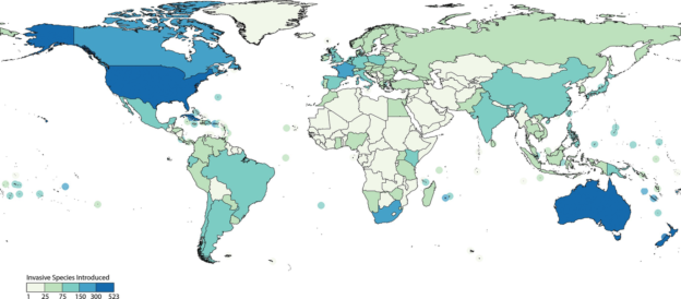
- Invasive Species Mapping: Learn about the meaning of invasive species and dive into the mapping of Slangbos vegetation in South Africa.
- Woody Cover Mapping: Understand the importance of woody vegetation in savanna environments and estimate amounts of fractional woody cover in South Africa.
3 Topics
Invasive Species Mapping
Learning objectives of this topic Gain understanding of the meaning of alien species.Learn how alien species can be monitored.Work with…
3 Topics
Woody Cover Mapping
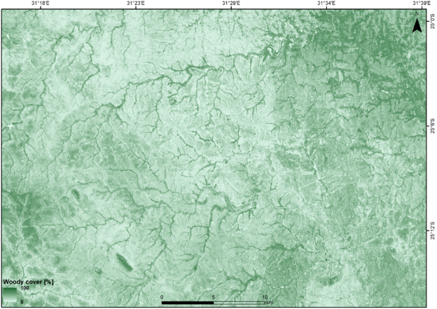
The figure above interactively displays the difference between a woody cover map derived from Sentinel-1 C-band data and Google Earth…
Note: you do not have to take the lessons in any particular order.
Related courses


Project partners


Course Content
About Instructor

Not Enrolled
Course Includes
- 2 Lessons
- 6 Topics
- 2 Quizzes
- Course Certificate
Login
Accessing this course requires a login. Please enter your credentials below!