Introduction
Listen to the Podcast
Persistent Scatterer Interferometry (PSInSAR) is an advanced radar remote sensing technique that utilizes Synthetic Aperture Radar (SAR) data to detect millimeter-scale ground deformations. X-band SAR, with its short wavelength (~3 cm) and high spatial resolution, is particularly well-suited for monitoring urban infrastructure, landslides, and subsidence phenomena. This essay explores the principles of PSInSAR, its applications using X-band data, and the challenges associated with its implementation.
Principles of PSInSAR
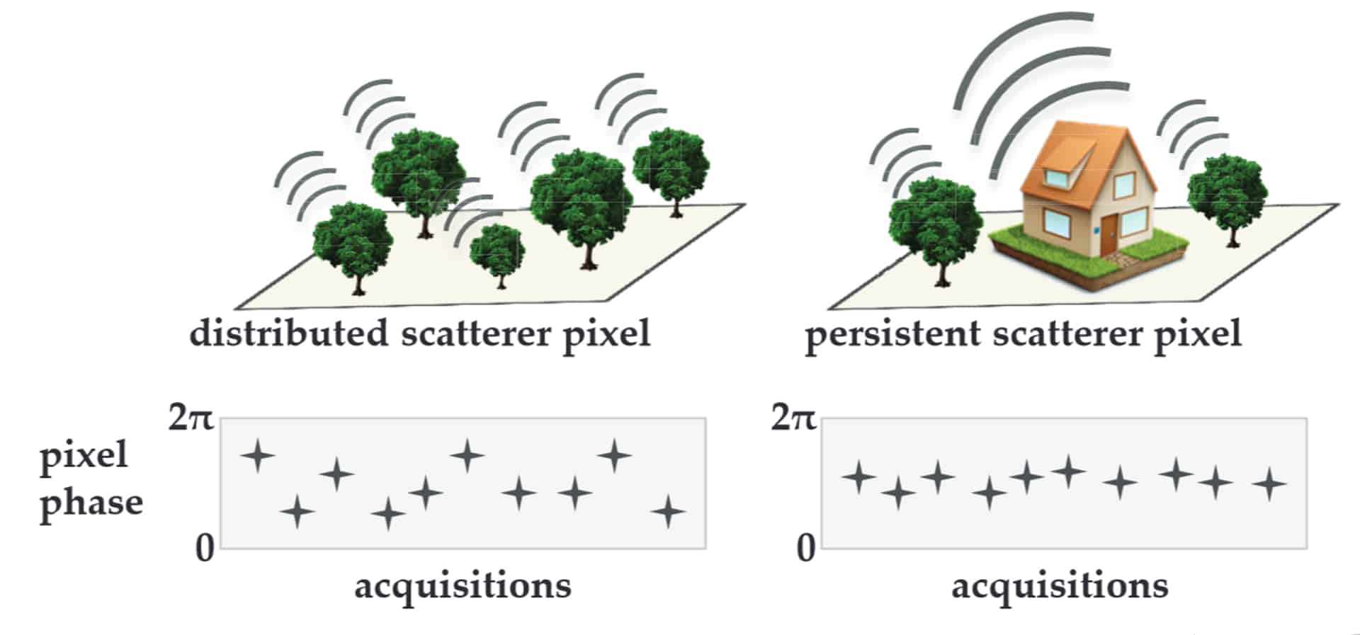
PSInSAR is based on the analysis of phase differences in multiple SAR acquisitions over time. The method exploits Persistent Scatterers (PS), which are stable reflectors that maintain a consistent radar signature across multiple observations. These are typically found in urban environments (e.g., buildings, bridges) and rocky terrains.
The core components of PSInSAR include:
- Interferogram Generation: Phase differences between SAR images are used to derive displacement measurements.
- Phase Unwrapping: Resolving ambiguities in phase differences to obtain absolute deformation values.
- Atmospheric Correction: Separating atmospheric artifacts from real displacement signals.
- Time-Series Analysis: Tracking deformation trends over extended periods.
Detailed Processing Steps
The PSInSAR method consists of several key processing steps:
- Data Acquisition and Preprocessing
- Multiple SAR images are acquired over the same area across different time intervals.
- Radiometric and geometric corrections are applied to ensure consistency among images.
- Coregistration of SAR images is performed to align them precisely at the pixel level.
- Interferogram Formation and Coherence Analysis
- Pairwise combinations of SAR images are used to generate interferograms, capturing phase differences between acquisitions.
- The coherence of each pixel is analyzed to identify stable scatterers that exhibit consistent backscatter over time.
- Persistent Scatterer (PS) Selection
- Stable radar reflectors (PS points) are identified using statistical approaches based on amplitude and phase stability.
- A network of PS points is established, linking scatterers with consistent phase evolution.
- Phase Unwrapping and Deformation Analysis
- The wrapped phase is converted into absolute phase values using advanced unwrapping algorithms.
- Deformation rates are estimated by fitting a time-series model to the phase evolution of each PS point.
- Atmospheric and Orbital Error Correction
- Atmospheric phase delays and orbital inaccuracies are corrected using spatiotemporal filtering techniques.
- A reference point with assumed zero deformation is selected to normalize phase measurements.
- Geolocation and Final Deformation Map Generation
- The final deformation map is generated by converting phase changes into displacement values.
- Results are georeferenced to a digital elevation model (DEM) to enhance spatial accuracy.
Advantages of X-Band SAR for PSInSAR
X-band SAR offers several advantages for Persistent Scatterer Interferometry:
- High Spatial Resolution: Provides detailed monitoring of infrastructure and urban deformation.
- Frequent Revisit Time: Some X-band satellite constellations (e.g., TerraSAR-X, COSMO-SkyMed) offer short revisit intervals, allowing near-real-time monitoring.
- Sensitivity to Small Deformations: The short wavelength enhances sensitivity to millimeter-scale surface displacements.
Applications of X-Band PSInSAR
1. Urban Infrastructure Monitoring
X-band PSInSAR is extensively used for monitoring buildings, bridges, and roads. It helps detect structural instabilities, subsidence, and uplift in densely built environments. For example, PSInSAR analysis has been employed in cities to assess the impact of underground construction projects, such as tunneling and metro expansions.
2. Landslide and Geohazard Detection
The ability to detect slow-moving landslides makes X-band PSInSAR valuable for geohazard assessment. By monitoring surface deformations over time, early warnings can be provided to mitigate disasters in mountainous and landslide-prone areas.
3. Subsidence Monitoring
Ground subsidence due to groundwater extraction, mining activities, or natural compaction can be effectively tracked using X-band PSInSAR. The technique has been applied to regions experiencing land subsidence, such as industrial zones and urban areas with excessive groundwater withdrawal.
4. Infrastructure Stability in Transportation Networks
Railways, highways, and airport runways can be monitored for surface deformations using PSInSAR. The high spatial resolution of X-band radar allows for precise tracking of infrastructure integrity, helping prevent catastrophic failures.
Challenges and Limitations
Despite its advantages, X-band PSInSAR faces several challenges:
- Limited Penetration in Vegetated Areas: The short wavelength makes X-band less effective in dense vegetation, where longer wavelengths (e.g., L-band) provide better penetration.
- Atmospheric Effects: X-band data is more susceptible to atmospheric distortions, requiring robust correction techniques.
- Shorter Coherence Time: Rapid decorrelation of X-band signals in non-urban environments can affect data consistency.
Conclusion
X-band PSInSAR is a powerful tool for monitoring ground deformation with high precision. Its applications in urban infrastructure, landslides, subsidence, and transportation networks make it invaluable for environmental monitoring and disaster mitigation. However, challenges such as atmospheric effects and limited penetration in vegetated areas necessitate the use of advanced correction methods and integration with other SAR frequencies for comprehensive analysis. Ongoing advancements in sensor technology and data processing will continue to enhance the capabilities of X-band PSInSAR, ensuring its relevance in geospatial analysis and earth observation.
Expand Your Knowledge – Dive Deeper
Further Reading
- Teatini, P., Tosi, L., & Strozzi, T. (2014). Capability of X-band persistent scatterer interferometry to monitor land subsidence in the venice lagoon. In Engineering Geology for Society and Territory–Volume 4: Marine and Coastal Processes (pp. 175-178). Cham: Springer International Publishing.
- Devanthéry, N., Crosetto, M., Monserrat, O., Crippa, B., & Mróz, M. (2019). Data analysis tools for persistent scatterer interferometry based on Sentinel-1 data. European Journal of Remote Sensing, 52(sup1), 15-25.
- Crosetto, M., Monserrat, O., Cuevas-González, M., Devanthéry, N., & Crippa, B. (2013). Analysis of X-Band very high resolution persistent scatterer interferometry data over urban areas. INTERNATIONAL ARCHIVES OF THE PHOTOGRAMMETRY, REMOTE SENSING AND SPATIAL INFORMATION SCIENCES, 40(1), 47-51.
- How persistent scatterer interferometry is used to predict and prevent infrastructure damage
Responses