Introduction
The SAOCOM program (Satélite Argentino de Observación Con Microondas) is Argentina’s leading Earth observation initiative, managed by its national space agency, CONAE (Comisión Nacional de Actividades Espaciales). SAOCOM focuses on deploying L-band Synthetic Aperture Radar (SAR) satellites, which are designed to collect data regardless of weather or lighting conditions. This makes them particularly valuable for monitoring environmental processes, agricultural lands, and disaster-affected regions.
SAOCOM plays a critical role in the SIASGE program (Italian-Argentinian Satellite System for Emergency Management), developed in partnership with Italy’s ASI (Agenzia Spaziale Italiana). By combining Argentina’s L-band radar satellites with Italy’s COSMO-SkyMed X-band constellation, SIASGE provides complementary data that strengthens emergency response and environmental monitoring.
The program consists of two phases: SAOCOM 1, which includes the operational satellites SAOCOM 1A and SAOCOM 1B, and SAOCOM 2, which will deploy SAOCOM 2A and SAOCOM 2B in the near future.
SAOCOM 1 Mission Overview
Objectives
The SAOCOM 1 mission focuses on acquiring L-band SAR imagery to monitor soil moisture, vegetation, and surface deformation. This data is essential for agriculture, disaster management, and environmental monitoring, and it supports early warning systems that reduce the impact of natural hazards.
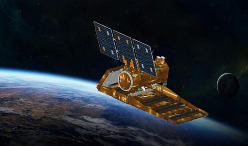
Satellites and Launches
- SAOCOM 1A was launched on October 7, 2018, aboard a SpaceX Falcon 9 rocket from Vandenberg Air Force Base.
- SAOCOM 1B followed on August 30, 2020, also via a Falcon 9, from Cape Canaveral.
Both satellites orbit the Earth in Sun-synchronous polar orbits at around 620 km altitude, enabling regular and consistent data acquisition over the same locations.
Technical Specifications
- Radar Frequency: L-band (1.275 GHz)
- Spatial Resolution: 7 meters to 100 meters, depending on the imaging mode
- Swath Width: 50 km to 400 km
- Polarimetry: Fully polarimetric (HH, HV, VH, VV)
- Revisit Time: 8 days for global coverage, improved through coordination with COSMO-SkyMed
Advantages of SAOCOM 1
Deep Penetration of L-band Radar
The longer wavelength of L-band SAR allows penetration through dense vegetation, snow, and soil layers. This makes SAOCOM 1 especially effective for monitoring soil moisture, forest biomass, and subsurface structures.
Consistent Data Collection
Because radar sensors can collect data in all weather conditions and at any time of day or night, SAOCOM 1 ensures continuous and reliable data availability. This is essential for applications such as disaster management and climate studies.
Contribution to Disaster Response
SAOCOM 1 provides near-real-time imagery in emergencies like floods, landslides, and earthquakes. Combined with COSMO-SkyMed data, SAOCOM 1 enhances multi-frequency SAR capabilities, offering more comprehensive information for risk management and disaster relief.
Applications in Agriculture
The soil moisture data collected by SAOCOM 1 supports precision agriculture by improving irrigation planning and monitoring crop health. This helps optimize water use and improve agricultural productivity, particularly in regions vulnerable to drought.
Scientific and Research Contributions
SAOCOM 1 data has been used in academic research and scientific studies. It has advanced SAR processing methods, polarimetric applications, and InSAR (Interferometric SAR) techniques for measuring ground deformation.
Disadvantages and Challenges of SAOCOM 1
Limited Revisit Time
Even with two satellites, SAOCOM 1’s revisit frequency is not as high as some commercial constellations. This limits its ability to monitor rapidly changing events on a daily basis.
Lower Spatial Resolution
While L-band SAR provides better penetration, it generally offers lower spatial resolution compared to X-band SAR systems like COSMO-SkyMed. This limits its use in applications that require detailed imaging, such as urban mapping.
High Operational Costs
Operating and maintaining L-band radar satellites is expensive. For CONAE, balancing financial resources between satellite operations and other national priorities can be challenging.
Applications of SAOCOM 1
Soil Moisture Monitoring
SAOCOM 1 generates soil moisture maps that are essential for agriculture, water resource management, and drought monitoring. These products help decision-makers in managing irrigation and adapting to changing climate conditions.
Disaster Response and Emergency Mapping
SAOCOM 1 provides rapid assessments of disaster zones, detecting floods, landslides, and earthquake damage. The data supports relief agencies in planning and executing emergency operations.
Forest and Land Use Monitoring
The L-band data from SAOCOM 1 is used for monitoring forest cover, estimating biomass, and detecting illegal logging activities. It also supports carbon credit programs by tracking forest carbon stocks.
Geohazard Monitoring
SAOCOM 1’s InSAR capability helps monitor ground deformation, subsidence, and landslides. This information is vital for urban planners, infrastructure managers, and geohazard early warning systems.
Marine and Coastal Monitoring
The system assists in monitoring coastal erosion, wetland changes, and detecting oil spills. This data supports coastal zone management and environmental protection efforts.
SAOCOM 2: The Next Generation
Mission Objectives
The SAOCOM 2 program builds on SAOCOM 1, offering continuity of L-band SAR observations while enhancing system performance. Its goals include increasing revisit frequency, expanding applications, and improving data accessibility.
Launch Timeline
- SAOCOM 2A is scheduled for launch in 2025.
- SAOCOM 2B is expected to follow in 2026.
These satellites will operate in Sun-synchronous orbits, like SAOCOM 1, ensuring consistent coverage.
Technological Improvements
- Higher Revisit Rates: SAOCOM 2 will complement SAOCOM 1 to provide more frequent imaging, ideal for time-sensitive monitoring.
- Improved Onboard Processing: Enhancements will speed up data delivery and reduce processing times.
- Increased Coverage: SAOCOM 2 will have greater data acquisition capacity, enabling coverage of wider areas and serving more users simultaneously.
- Synergy with COSMO-SkyMed Second Generation: SAOCOM 2 will strengthen SIASGE by integrating with Italy’s COSMO-SkyMed Second Generation satellites, providing multi-frequency radar data for more comprehensive Earth observation.
Conclusion
SAOCOM 1 has successfully demonstrated Argentina’s ability to develop and operate advanced space-based radar systems. Its contributions to agriculture, disaster management, and environmental monitoring have proven valuable both nationally and internationally.
SAOCOM 2 is expected to extend these benefits, providing enhanced monitoring capabilities, faster data delivery, and improved temporal resolution. As part of the SIASGE system, SAOCOM 2 highlights the value of international collaboration in advancing Earth observation technologies for sustainable development and disaster resilience.
Together, SAOCOM 1 and SAOCOM 2 represent a long-term commitment by Argentina and its partners to using space technology for scientific research, disaster management, and environmental protection on a global scale.
Expand Your Knowledge – Dive Deeper
Further Reading
- Giraldez, A.E., 2004. SAOCOM-1 Argentina L-band SAR mission overview. ESA Special Publication 565, 27.
- CONAE web site with technical characteristics of the SAOCOM SAR
- MundoGEO: Argentina prepares second generation of SAOCOM satellites
- SAOCOM Sample Data
Responses