

Learning objectives of this topic
- Introduction to RS data download
- Workflow of downloading remote sensing data
- Examples of platforms for data access
Now that you have learned about the ways of how to process and interpret remote sensing data the important question is:
Where can I download remote sensing imagery?
There are several data platforms, where free remote sensing data can be downloaded. They can be differentiated by the Space Agency or institution that built them and the type of data that is offered. However, they have one important thing in common: they are all free of charge!
Steps to download remotely sensed data:
1 – Register your account on the platform
2 – Define your area of interest (AOI) by drawing a certain extent or upload a shapefile.
3 – Define the dates between you want to look for satellite scenes.
4 – Select your desired product (e.g. Sentinel-1 or MODIS).
5 – Select details regarding the sensing date:
a) Processing level (e.g. Level-2 – usually analysis-ready)
b) Cloud cover (% cloud cover)
c) Orbits or certain acquisition modes
6 – Sieve your search results by checking footprints or thumbnails.
7 – Download your data sets!
ESA’s Copernicus Open Access Hub
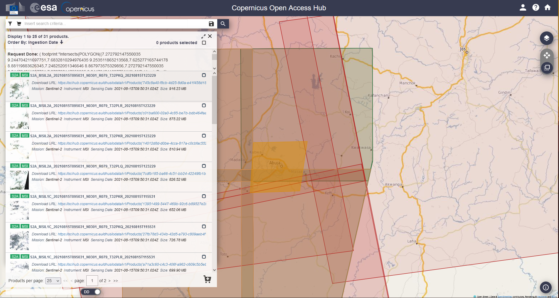
If you want to download recent Sentinel data, the Copernicus Open Access Hub is the go-to address. It provides different levels of processing for each of the available satellites (Sentinel-1,-2,-3,-5P). They report interesting stats and have a very informative documentation. Downtimes are always announced in time (e.g., technical changes on the platform), so that users can adjust accordingly. You can download data via GUI or automate it through several interfaces (Python, aria, etc.).
One thing you have to keep in mind, when planning on using Sentinel data downloaded from the Copernicus Hub is that this is a rolling archive. This means that the data stored there will be removed at some point in time to free space for new acquisitions. The duration over which data is deleted is dependent on the data set (e.g., 18 months for Sentinel-2 L2A). Alternatively you can also access older Sentinel-1 data through the Alaska Satellite Facility (ASF) as well as Amazon Web Services (AWS) in order to download Sentinel-2 imagery (managed by Singergise). Sentinel-2 imagery can also be downloaded through the USGS Earth Explorer.
At the beginning of the 4th quarter of 2021, the Hub provided user downloads of approximately 380 Petabytes (that’s 380,000 TB).
Take a look at the video below to learn, instructed by Christopher Stewart, how you can search and download data from the Copernicus Open Access Hub.

By loading the video, you agree to YouTube’s privacy policy.
Learn more
USGS Earth Explorer

The USGS Earth Explorer is one of the best platforms for downloading remote sensing data. There are lots of options in search criteria and the sequential arrangement of satellite images, which makes it easy to access the data. The full access to NASA’s Land Data Products and Services provide a variety of satellite and aerial images. Besides satellite data from Landsat and other missions governed by NASA, you can also download aerial imagery and other cartographic products. Data provided covers not only the United States of America but partly also the globe. In contrast to the Copernicus Hub, you cannot directly download from their website but through a download link, you receive after submitting your query in the explorer.
Alaska Satellite Facility (ASF)
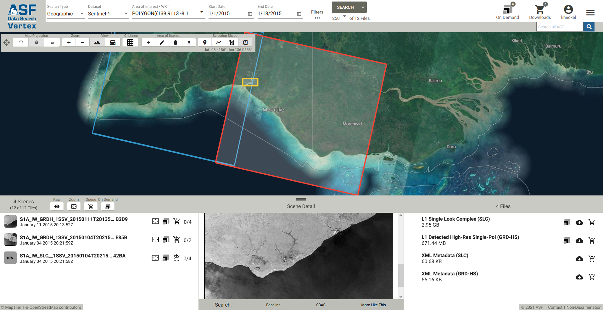
Another great portal is NASA’s Alaska Satellite Facility (ASF) Distributed Active Archive Center (DAAC) Data Search Vertex. This platform focuses on the distribution of microwave data. You will find data from a variety of synthetic aperture radar (SAR) sensors such as ALOS PALSAR, SIR-C, SMAP, JERS-1 or Sentinel-1. You might wonder, “Why would I download Sentinel-1 data here and not directly from the ESA portal?”. Well, one reason could be that this is not a rolling archive when it comes to Sentinel-1 data. This means that you can find ‘historic’ C-Band data from Sentinel-1 that is not stored on the Copernicus Hub anymore.
Learning objectives of this topic
- Introduction to RS data download
- Workflow of downloading remote sensing data
- Examples of platforms for data access
Now that you have learned about the ways of how to process and interpret remote sensing data the important question is:
Where can I download remote sensing imagery?
There are several data platforms, where free remote sensing data can be downloaded. They can be differentiated by the Space Agency or institution that built them and the type of data that is offered. However, they have one important thing in common: they are all free of charge!
Steps to download remotely sensed data:
1 – Register your account on the platform
2 – Define your area of interest (AOI) by drawing a certain extent or upload a shapefile.
3 – Define the dates between you want to look for satellite scenes.
4 – Select your desired product (e.g. Sentinel-1 or MODIS).
5 – Select details regarding the sensing date:
a) Processing level (e.g. Level-2 – usually analysis-ready)
b) Cloud cover (% cloud cover)
c) Orbits or certain acquisition modes
6 – Sieve your search results by checking footprints or thumbnails.
7 – Download your data sets!
ESA’s Copernicus Open Access Hub
If you want to download recent Sentinel data, the Copernicus Open Access Hub is the go-to address. It provides different levels of processing for each of the available satellites (Sentinel-1,-2,-3,-5P). They report interesting stats and have a very informative documentation. Downtimes are always announced in time (e.g., technical changes on the platform), so that users can adjust accordingly. You can download data via GUI or automate it through several interfaces (Python, aria, etc.).
One thing you have to keep in mind, when planning on using Sentinel data downloaded from the Copernicus Hub is that this is a rolling archive. This means that the data stored there will be removed at some point in time to free space for new acquisitions. The duration over which data is deleted is dependent on the data set (e.g., 18 months for Sentinel-2 L2A). Alternatively you can also access older Sentinel-1 data through the Alaska Satellite Facility (ASF) as well as Amazon Web Services (AWS) in order to download Sentinel-2 imagery (managed by Singergise). Sentinel-2 imagery can also be downloaded through the USGS Earth Explorer.
At the beginning of the 4th quarter of 2021, the Hub provided user downloads of approximately 380 Petabytes (that’s 380,000 TB).
Take a look at the video below to learn, instructed by Christopher Stewart, how you can search and download data from the Copernicus Open Access Hub.
By loading the video, you agree to YouTube’s privacy policy.
Learn more
USGS Earth Explorer
The USGS Earth Explorer is one of the best platforms for downloading remote sensing data. There are lots of options in search criteria and the sequential arrangement of satellite images, which makes it easy to access the data. The full access to NASA’s Land Data Products and Services provide a variety of satellite and aerial images. Besides satellite data from Landsat and other missions governed by NASA, you can also download aerial imagery and other cartographic products. Data provided covers not only the United States of America but partly also the globe. In contrast to the Copernicus Hub, you cannot directly download from their website but through a download link, you receive after submitting your query in the explorer.
Alaska Satellite Facility (ASF)
Another great portal is NASA’s Alaska Satellite Facility (ASF) Distributed Active Archive Center (DAAC) Data Search Vertex. This platform focuses on the distribution of microwave data. You will find data from a variety of synthetic aperture radar (SAR) sensors such as ALOS PALSAR, SIR-C, SMAP, JERS-1 or Sentinel-1. You might wonder, “Why would I download Sentinel-1 data here and not directly from the ESA portal?”. Well, one reason could be that this is not a rolling archive when it comes to Sentinel-1 data. This means that you can find ‘historic’ C-Band data from Sentinel-1 that is not stored on the Copernicus Hub anymore.